






America’s deepest man-made lakes were created by flooding ancient river valleys behind massive dams; here’s the list | World News
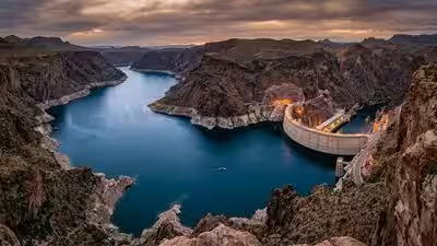
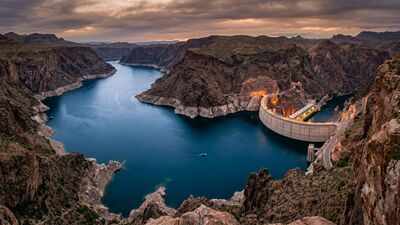
Deepest man-made lakes in the United States were not created by nature but by engineering on an enormous scale. Before these reservoirs existed, many were steep river valleys and rugged canyons carved over thousands of years. During the 20th century, massive dams blocked flowing rivers, allowing water to fill these landscapes and form deep reservoirs that now provide drinking water, generate hydroelectric power and help control flooding. Their depth is not fixed, however. Water levels rise and fall with changing weather, drought and demand, meaning the deepest point is reached only when the reservoirs are full. Measuring them at maximum capacity offers the clearest picture of which artificial lakes are truly the deepest in the country.Explore the 10 deepest man-made lakes in the United States, according to WorldAtlas.
List of America’s deepest man-made lakes
Deepest man-made lakes in the US
Lake Oroville
Lake Oroville sits in the foothills of Northern California and reaches a maximum depth of 690 feet when completely full. The reservoir was created after the construction of Oroville Dam on the Feather River, a project that became one of the most important parts of California’s water system.The reservoir covers more than 15,000 acres and has a shoreline stretching for more than 160 miles. Its steep underwater terrain is a reminder that the lake occupies a river valley rather than a naturally formed basin.
Dworshak Reservoir
Dworshak Reservoir reaches depths of around 650 feet, making it the second-deepest man-made lake in the country. Located along the North Fork of the Clearwater River, the reservoir extends deep into the forested landscape of northern Idaho.The reservoir was formed by Dworshak Dam, one of the tallest dams in the United States. Construction was completed in the 1970s, mainly to provide flood control and hydroelectric power.Unlike many busy recreational lakes, Dworshak retains a remote character. Its long, narrow shape follows the original river canyon, with mountains rising around much of the shoreline. Fishing, boating, and hiking remain popular activities, particularly because large sections of the surrounding landscape remain undeveloped.
New Bullards Bar Reservoir
In northern California, New Bullards Bar Reservoir reaches 620 feet at its deepest point. The lake was created by the New Bullards Bar Dam on the Yuba River and serves several roles, including water storage, flood management, irrigation support, and power generation.The reservoir stretches for roughly 15 miles through forested foothills near the Tahoe and Plumas National Forests. Much of its appeal comes from the contrast between the deep blue water and the rugged terrain surrounding it.The lake also attracts visitors for boating, fishing, camping, and hiking. Some trails climb away from the shoreline into higher forest areas, offering views of a landscape that was dramatically reshaped after the valley was flooded.
Lake Powell and Lake Mead
The Colorado River is home to two of the most recognised reservoirs in the United States. Both were built to manage water supplies in the arid Southwest, where rivers must support millions of people, farms, and industries.Lake Powell reaches a maximum depth of about 583 feet near Glen Canyon Dam. The reservoir began filling in the 1960s after the dam was completed, eventually creating one of the largest artificial lakes in the country by surface area.Its unusual shape comes from the flooded canyons of the Colorado River system. Hundreds of side canyons branch away from the main channel, creating a landscape popular with boaters and visitors exploring the desert waterways.
Shasta Lake
Shasta Lake reaches a maximum depth of 517 feet and plays a central role in California’s water network. The reservoir was created by Shasta Dam on the Sacramento River during the 20th century.The project was designed to help manage water shortages and flooding in California’s Central Valley, an agricultural region that depends heavily on controlled water supplies.Today, Shasta Lake is also known as a recreation destination. The surrounding Shasta-Trinity National Forest provides opportunities for hiking, camping, and horseback riding, while the lake itself attracts boaters, swimmers, and anglers.
Carters Lake
Carters Lake in Georgia reaches depths exceeding 450 feet, making it the deepest man-made lake in the state. Created by Carters Dam in the late 1970s, it was built mainly for flood control and power generation.The lake sits among the Blue Ridge Mountains and has remained relatively undeveloped compared with many reservoirs. Its wooded shoreline and clear water give it a more natural appearance than many engineered lakes.
Fontana Lake
In North Carolina, Fontana Lake reaches 440 feet deep. The reservoir borders large sections of the Great Smoky Mountains National Park and was formed by Fontana Dam during the 1940s.The Appalachian Trail crosses directly over the top of the dam, making the site unusual among major American reservoirs. While boating and fishing are common, the lake is also closely tied to the surrounding mountain landscape.
Flaming Gorge Reservoir
Flaming Gorge Reservoir extends nearly 90 miles through parts of Utah and Wyoming. Formed by Flaming Gorge Dam on the Green River, it reaches 436 feet at its deepest point.The reservoir supports water management in the region and provides habitat for wildlife, while its dramatic cliffs and narrow sections make it a popular destination for boating and fishing.
Lake Koocanusa
Farther north, Lake Koocanusa crosses an international boundary. Created by Libby Dam on the Kootenai River, the reservoir stretches from Montana into Canada and reaches a maximum depth of 348 feet.Its name combines parts of Kootenai, Canada, and USA, reflecting its unusual location. The lake’s long shoreline, mountain setting, and remote campsites have made it a favourite destination for visitors seeking outdoor recreation.
The hidden landscapes beneath America’s largest reservoirs
America’s deepest man-made lakes began as narrow river valleys rather than open expanses of water. During the 20th century, engineers built huge dams across steep canyons, allowing rivers to back up and form vast reservoirs that now supply drinking water, generate hydroelectric power and reduce flood risk. Beneath many of these lakes lie submerged valleys that plunge hundreds of feet below the surface, making their true scale difficult to appreciate from above. Because reservoir levels rise and fall with rainfall, drought and water demand, their depth is never constant.